|
|


 01-08-2009, 09:43 PM
|
#1 |
|
Avalon Senior Member
Join Date: Sep 2008
Location: So. Cal. U.S.
Posts: 4,205
|
SAN JOSE, Costa Rica A strong earthquake shook Costa Rica on Thursday, shattering windows, cracking walls and sending frightened residents running into the streets of the capital.
There were no immediate reports of injuries or major damage. The U.S. Geological Survey said the 6.1 magnitude temblor was centered 22 miles (35 kilometers) northwest of the capital of San Jose in the early afternoon, near the Poas Volcano national park. The quake's depth was measured at 28 miles (35 kilometers). Local TV station Teletica showed broken windows, fallen ceiling panels and cracked walls in the city of Alajuela, north of the capital. Teletica said the quake was felt strongly throughout the small Central American country. Security Minister Jeanina del Vecchio urged people to remain calm while authorities surveyed areas to see if there was major damage. Thousands of people ran from homes and shopping centers, frightened by the quake. The quake triggered small landslides outside the capital, and cell phone service was interrupted briefly There were at least four aftershocks. 
|

|

|
|
01-08-2009, 09:53 PM
|
#2 |
|
Avalon Senior Member
Join Date: Sep 2008
Location: UK
Posts: 660
|
Thanks for this!
I've been watching this seismic site daily - http://www.iris.edu/seismon/last30.html Some places are really rocking at the moment! I am always suspicious of the 10km deep ones, and now it appears that 35km is commonplace - as they are usually in contentious areas. Keep checking the depths (as these dictate the damage - the shallower the more devastating), check for similarities in depths. Lets hope Costa Rica settles down asap! |
|
|
|
|
01-08-2009, 10:16 PM
|
#3 |
|
Avalon Senior Member
Join Date: Sep 2008
Location: Scotland
Posts: 126
|
We've been noticing the 10ks and 35ks as well and a friend has offered to ask a seismologist if these depths are just the thickness of the earth's crust or what.
love to all especially those on shaky ground |
|
|
|
|
01-08-2009, 10:32 PM
|
#4 |
|
Avalon Senior Member
Join Date: Sep 2008
Location: So. Cal. U.S.
Posts: 4,205
|
Here you go.......
How Thick Is the Earth's Crust? We present a new contour map of the thickness of the Earth's crust. We use a 10 km contour interval plus the 45 km contour. This contour map was created directly from the 5 deg. by 5 deg. gridded crustal model CRUST 5.1 (Mooney et al., 1998) plus complimentary information. An initial contour map was created using the command "grdcontour" in GMT, and the resultant map was adjusted in Adobe Illustrator to honor individual point measurements and newly available information from Russia. The final contour map honors all available seismic refraction measurements for features with a dimension greater than 2 degrees. To a first approximation, the continents and their margins are outlined by the 30 km contour. That portion of the continental interior enclosed by the 40 km contour, and regions with crustal thickness of 45 to 50 km are found on all well surveyed continents (i.e., North and South America, Australia, and Eurasia). Continental crust with a thickness in excess of 50 km is exceedingly rare and accounts for less than 10% of the continental crust. These observations, now available on a global basis, provide important constraints on the evolution of the crust and sub-crustal lithosphere.  This contour map of the thickness of the Earth's crust was developed from the CRUST 5.1 model. The contour interval is 10 km; we also include the 45 km contour for greater detail on the continents. |
|
|
|
|
01-08-2009, 11:15 PM
|
#5 |
|
Avalon Senior Member
Join Date: Sep 2008
Location: Scotland
Posts: 126
|
Thanks for the map Dantheman. At first glance some 10ks make sense, but others don't eg the recent one in southern Sweden.
love to all |
|
|
|
|
01-08-2009, 11:30 PM
|
#6 |
|
Avalon Senior Member
Join Date: Sep 2008
Location: UK
Posts: 660
|
Thanks for the map - however - on the seismic charts,
including this other one http://neic.usgs.gov/neis/qed/ there are depths such as 235.7 PERU-BOLIVIA BORDER REGION 69.5 NEAR COAST OF NICARAGUA 111.6 ECUADOR so why the consistently 'rounded-off' figures such as 10 and 35??? Surely not all faults occur at these consistent depths? Something is wrong with the system? |
|
|
|
|
01-08-2009, 11:39 PM
|
#7 |
|
Avalon Senior Member
Join Date: Sep 2008
Location: So. Cal. U.S.
Posts: 4,205
|
Here's some more info!....
All About Plate Tectonics: Earth's Plates and Continental Drift 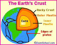 The Earth's rocky outer crust solidified billions of years ago, soon after the Earth formed. This crust is not a solid shell; it is broken up into huge, thick plates that drift atop the soft, underlying mantle. The Earth's rocky outer crust solidified billions of years ago, soon after the Earth formed. This crust is not a solid shell; it is broken up into huge, thick plates that drift atop the soft, underlying mantle. The plates are made of rock and drift all over the globe; they move both horizontally (sideways) and vertically (up and down). Over long periods of time, the plates also change in size as their margins are added to, crushed together, or pushed back into the Earth's mantle. These plates are from 50 to 250 miles (80 to 400 km) thick. 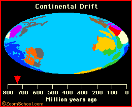 Forward Backward Forward Backward The map of the Earth is always changing; not only are the underlying plates moving, but the plates change in size. Also, the sea level changes over time (as the temperature on Earth varies and the poles melt or freeze to varied extents), covering or exposing different amounts of crust. Earth's Major Plates: 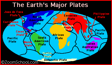 The current continental and oceanic plates include: the Eurasian plate, Australian-Indian plate, Philippine plate, Pacific plate, Juan de Fuca plate, Nazca plate, Cocos plate, North American plate, Caribbean plate, South American plate, African plate, Arabian plate, the Antarctic plate, and the Scotia plate. These plates consist of smaller sub-plates.  PLATE TECTONICS Type of CrustAverage ThicknessAverage AgeMajor ComponentContinental Crust20-80 kilometers3 billion yearsGraniteOceanic Crust10 kilometersGenerally 70 to 100 million years oldBasaltThe theory of plate tectonics (meaning "plate structure") was developed in the 1960's. This theory explains the movement of the Earth's plates (which has since been documented scientifically) and also explains the cause of earthquakes, volcanoes, oceanic trenches, mountain range formation, and many other geologic phenomenon. The plates are moving at a speed that has been estimated at 1 to 10 cm per year. Most of the Earth's seismic activity (volcanoes and earthquakes) occurs at the plate boundaries as they interact. 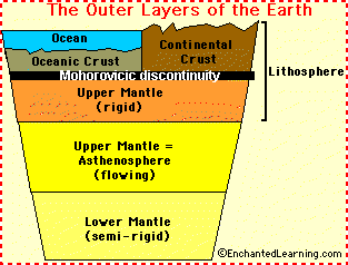 The top layer of the Earth's surface is called the crust (it lies on top of the plates). Oceanic crust (the thin crust under the oceans) is thinner and denser than continental crust. Crust is constantly being created and destroyed; oceanic crust is more active than continental crust. Under the crust is the rocky mantle, which is composed of silicon, oxygen, magnesium, iron, aluminum, and calcium. The upper mantle is rigid and is part of the lithosphere (together with the crust). The lower mantle flows slowly, at a rate of a few centimeters per year. The asthenosphere is a part of the upper mantle that exhibits plastic properties. It is located below the lithosphere (the crust and upper mantle), between about 100 and 250 kilometers deep. The top layer of the Earth's surface is called the crust (it lies on top of the plates). Oceanic crust (the thin crust under the oceans) is thinner and denser than continental crust. Crust is constantly being created and destroyed; oceanic crust is more active than continental crust. Under the crust is the rocky mantle, which is composed of silicon, oxygen, magnesium, iron, aluminum, and calcium. The upper mantle is rigid and is part of the lithosphere (together with the crust). The lower mantle flows slowly, at a rate of a few centimeters per year. The asthenosphere is a part of the upper mantle that exhibits plastic properties. It is located below the lithosphere (the crust and upper mantle), between about 100 and 250 kilometers deep. http://www.enchantedlearning.com/sub...ntinents.shtml |
|
|
|
|
01-09-2009, 01:53 AM
|
#8 |
|
Avalon Senior Member
Join Date: Sep 2008
Location: So. Cal. U.S.
Posts: 4,205
|
Hope that helps, there's a lot of info out there!
|
|
|
|
 |
«
Previous Thread
|
Next Thread
»
 Linear Mode

|
|

All times are GMT. The time now is 10:58 PM.